

By:
- Robert Monroe
Published Date
By:
- Robert Monroe
Share This:
Why Was the 2015-16 El Niño Event So Dry?
Researchers uncover clues why powerful El Niño yielded little precipitation in California
Most long-range forecast models predicted a potentially drought-ending deluge in California from the climate pattern known as El Niño in winter 2015-16, but the actual precipitation was far less than expected.
A National Science Foundation-supported study led by climate scientists at Scripps Institution of Oceanography at the University of California San Diego offers an explanation why.
“Comparing this El Niño to previous strong El Niños, we found big differences in the atmospheric response across the globe, including California,” said Nick Siler, lead author of the study that was published in the Journal of Climate, and a postdoctoral scholar in the research group of co-author Shang-Ping Xie at Scripps. “We found that these differences weren’t all random, but rather were caused by tropical sea-surface temperature anomalies unrelated to El Niño.”
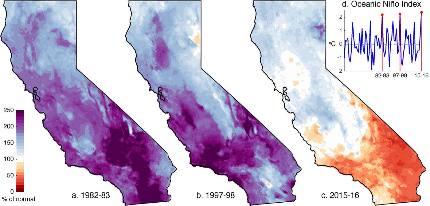
Winter precipitation as percentage of the 1980-2016 average, during each of the three strongest El Niños ever recorded.
The 2015-16 event possessed most of the classic defining features of an El Niño event. Water temperatures in the eastern equatorial Pacific Ocean were more than 2° C (3.6° F) above average, as they had been during previous strong El Niño events in 1982-83 and 1997-98. While those years saw 150 percent of average precipitation or more fall in California, 2015-16 precipitation totals were much lower, and were even below the average for non-El Niño years. This was not what most climate models had forecast.
The researchers compared environmental conditions during all three El Niño events with predictions from seasonal forecast models. The key features that were different in 2015-16 compared to previous El Niños were sea-surface temperature and rainfall in the Indian Ocean and western Pacific Ocean. The atmospheric response to these anomalies meant that storms that might otherwise have made landfall in California were pushed further north, bringing record precipitation to the Pacific Northwest instead. The team showed that the erroneous predictions of a wet winter in California were due in part to the inability of most models to forecast this sea-surface temperature anomaly. Random variability in the atmosphere was also found to play a role.
The results of the study suggest that El Niño events might not have as strong an influence on California precipitation as previously thought. They also suggest that recent warming might have had a hand in making El Niño drier. The Indian Ocean is known to be warming faster than other ocean basins. In 2015-16, sea-surface temperatures in that region broke the previous record high by nearly half a degree Celsius.
“Time will tell if the recent pattern of [sea-surface temperature] warming is a response to anthropogenic forcing, or primarily the result of low-frequency natural variability,” the authors concluded. “The answer could have important consequences for the future of California’s water resources.”
Co-authors of the study include former Scripps researcher Yu Kosaka, now of the University of Tokyo, and Xichen Li of the Chinese Academy of Sciences in Beijing. The work was supported through NSF grant 1637450.
Share This:
You May Also Like


Stay in the Know
Keep up with all the latest from UC San Diego. Subscribe to the newsletter today.