

SDSC Participates in CalWater Extreme Precipitation Project
Partnership Uses ‘Gordon’ Supercomputer for Experimental Real-Time Forecasts
Published Date
By:
- Jan Zverina
Share This:
Article Content
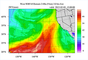
This video shows a 10-day forecast of the recent Atmospheric River (AR) event as it forms and impinges on the west coast of North America. The variable being forecast is IWV (Integrated Water Vapor); an estimate of the total amount of water in the atmosphere, and a well-established indicator of AR conditions when its value is large (>2 cm) and the characteristics structure is present (i.e. long and narrow in the mid latitudes). Hot colors (red) indicate high values; cool colors (blue) indicate low values. Andrew Martin/SIO and John Helly/SDSC, SIO
The San Diego Supercomputer Center (SDSC) and the University of California, San Diego, is providing data management, visualization and modeling resources, and expertise to a two-month wintertime field campaign to study “atmospheric rivers” and particles of dust, smoke, sea spray, and organic materials called aerosols along the western U.S. coast to better understand variability in the region’s water supply, flood and drought hazards, infrastructure requirements, and optimal reservoir operations.
The latest initiative, called the CalWater 2015 project, assembled a team of federal and state agencies plus academic research institutions collaborating in a tightly-coordinated effort involving ground-based observations, air and sea-borne measurements, and advanced weather forecast models.
CalWater 2015 is being led by scientists from the Scripps Institution of Oceanography at UC San Diego in collaboration with federal, state, and academic colleagues. Other partners in the project include the National Oceanographic and Atmospheric Administration (NOAA), Department of Energy (DOE), California Department of Water Resources (DWR), National Science Foundation (NSF), National Atmospheric and Space Administration (NASA), Colorado State University (CSU), Hebrew University of Jerusalem, Plymouth State University (PSU), North Carolina State University (NCSU), and the Naval Research Laboratory (NRL). A full overview of the latest project can be viewed here.
One goal of the CalWater 2015 project is to conduct weather and climate research to better understand the earth's physical environment, and to improve weather and climate predictions at the regional and local levels for a better understanding of western weather and water extremes. As a follow-on to the first CalWater project started in 2009, collected data will be analyzed to develop methods that can inform new protocols for hazard response and more effective water resource management as California copes with one of the most severe droughts on record.
This year, the ambitious undertaking involves deploying a fleet of four planes and one research ship packed with sophisticated sensors, a coastal super-site for chemistry and clouds, as well as constant monitoring from unique field sites across California sponsored by the state’s Department of Water Resources to track the activities of atmospheric rivers – narrow belts of moving airborne water vapor that can extend thousands of miles across the ocean and strike the West Coast. These atmospheric rivers are estimated to produce 30 to 50 percent of northern California’s annual precipitation.
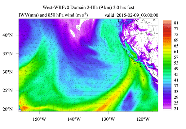
Image from a 15-hour forecast of IWV (Integrated Water Vapor); an estimate of the total amount of water in the atmosphere that could become precipitation. CalWater 2015 provides an opportunity to test new forecast methods by challenging them with observational data. Hot colors (red) indicate high values; cool colors (blue) indicate low values. The arrows are wind barbs indicating wind speed and direction. Andrew Martin/SIO and John Helly/SDSC, SIO
Daily mission-planning meetings are supported by West-WRF model forecasts being run in operational forecast mode on SDSC’s data-intensive Gordon supercomputer for Scripps’ new Center for Western Weather and Water Extremes (CW3E). Twice-daily forecasts are produced to help determine the optimal deployment of the ship and aircraft. SDSC’s high-performance computing and communications make it possible to move massive amounts of data quickly from computers to decision-makers.
For California, and more generally the West, it is essential that meteorologists and researchers can predict where, when, and how much precipitation will arrive as snow – usually good news because it can store water in slow-melting mountain snow packs – or rain, which may mean increased risk of flooding.
CalWater scientists also are eager to measure aerosols carried by these rains to get a better sense of their effect on the overall environment. When moisture from a landfalling atmospheric river is lofted by mountains, airborne aerosols are key to the formation of clouds and precipitation, and ultimately can influence precipitation amounts.
“My job has been to employ a research weather forecast model as a real-time experimental tool that we can use for daily operational mission planning using SDSC resources,” said John Helly, Laboratory Director for Earth and Environmental Science at SDSC and Scripps, and the campaign’s Data Management Working Group lead responsible for assembling the data collection at SDSC that will be used for years to come in analyzing the results of Calwater 2015.
“This is one of the most exciting projects I have had the opportunity to contribute to,” added Helly. “Western water and weather concerns are focused at the intersection of climate and weather, and we are now just learning how connect the spatial and temporal hydrological scales in a way that will help us manage and anticipate our water needs in a changing climate.”
“The development of a weather prediction model tailored to predicting extreme precipitation, and the atmospheric rivers that generate most of the heaviest rain and flooding in the west coast states, is a major effort at CW3E,” said Marty Ralph, director of the new center. “SDSC’s state-of-the-art capabilities are part of the foundation of this new modeling effort we call West-WRF, and CalWater 2015 is serving as an ideal proving ground for the initial testing of this new tool.”
Share This:
You May Also Like


Stay in the Know
Keep up with all the latest from UC San Diego. Subscribe to the newsletter today.