
UC San Diego Cyber-Archaeology Researchers Launch Crowdsourcing Portal to Monitor At-Risk Sites
Published Date
By:
- Doug Ramsey
Share This:
Article Content
Terrorism, turmoil and environmental damage pose critical threats to at-risk archaeological sites and artifacts in the Middle East, but a team of researchers based at the University of California San Diego is tapping the power of the ‘crowd’ to monitor damage to far-flung sites in the region.
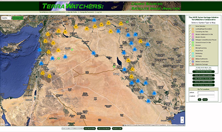
Screen shot shows distribution of 500 observations made in first week of TerraWatchers project with ASOR, which kicked off May 7. Some 700 sites were visited in first week by UC San Diego students.
In a joint project with the American Schools of Oriental Research (ASOR) Cultural Heritage Initiatives, UC San Diego’s new Center for Cyber-Archaeology and Sustainability (CCAS) is working with the year-old crowdsourcing portal TerraWatchers to carry out a joint online mission to monitor nearly 11,000 archaeological sites located in Syria, Iraq and Lebanon.
CCAS and TerraWatchers will recruit at least 100 students across four University of California campuses to analyze satellite imagery of the three countries. CCAS is a joint venture of the Qualcomm Institute and the Division of Social Sciences at UC San Diego.
“When we approached ASOR about how many people were regularly analyzing satellite images for evidence of destruction at archaeological sites in the region, we were told that ASOR had only two GIS experts tasked with that effort, even though hundreds more are needed,” said UC San Diego archaeologist and anthropology professor Thomas E. Levy (who also chairs ASOR’s Committee on Archaeological Policy). “One part of our new grant from the UC Office of the President – to document and analyze At-Risk Cultural Heritage in the Digital Humanities [ARCH] -- is to promote ‘citizen science’, and crowdsourcing is a great way to address that issue.”
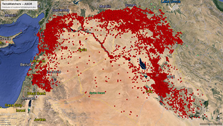
Google Earth image shows all the sites the TerraWatchers Collaborative will be monitoring.
Added Levy: “We are especially excited to work with the ASOR Syria Initiative led by Dr. Michael Danti, as a way of fully engaging University of California archaeologists and their students with pressing cultural heritage issues of the day. ”
CCAS did not have to build a crowdsourcing solution from scratch because its senior Research Affiliate (and longtime Levy collaborator), archaeologist Stephen Savage, built an online crowdsourcing portal for satellite image analysis in early 2015. The pilot study focused on the impact of military activity and looting on archaeological sites in Lebanon, Syria and Iraq.
“We piloted TerraWatchers through its first trial mission, after recruiting 60 volunteers last summer from GIS Corps, a non-profit group of some 4,000 volunteer experts in GIS, similar to Médecins Sans Frontières for doctors,” explained Savage. “Those GIS volunteers pored through satellite imagery of 2,500 sites in Lebanon, Syria and Iraq looking for by-products of military activity, and annotating the images with symbols for nine different types of damage from looting to bomb craters.”
The pilot project proved to be a valuable exercise because many of the GIS volunteers’ observations turned out to be wrong. “On the upside, they were finding everything to be found,” admitted Savage, “but they also ‘found’ looting and other damage that was not really there. They got a lot of false-positives, where they attributed damage to looting, for instance, but the terrain was not damaged at all.”
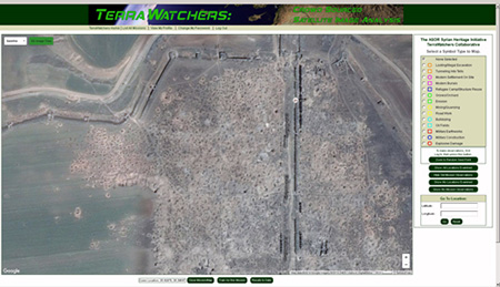
Screen shot of the TerraWatchers web application, with map zoomed in to the Classical period city of Apamea in Syria. Image shows extensive looting/pothunting holes inside the city walls.
With that finding, Levy and Savage recognized the importance of training, especially for citizen scientists. In the Spring quarter, the ASOR Cultural Heritage Initiatives-TerraWatchers Collaborative was extended to 20 students in Levy’s undergraduate class on “Archaeology, Anthropology and the Bible,” and five graduate students in his Levantine and Cyber-Archaeology Lab. He invited Savage to train the students in satellite imagery analysis during an April 7-8 visit to the UC San Diego campus. The 25 students are now registered TerraWatchers, and in the first 24 hours after the training session, the students had ‘visited’ 700 satellite images and made 500 observations (tagging points with apparent damage in or near the at-risk site).
“It’s important to get students trained on this because the kinds of things we are looking for can be very subtle,” explained Savage. “In the initial mission, the false positives ended up creating much more work for me than if I had done all the analysis myself. However, additional training can mitigate most of the false positives going forward.”
CCAS has set a target of at least 100 students registered on the TerraWatcher portal, primarily from UC San Diego and its three UC partner campuses in the ARCH project: UCLA, UC Berkeley and UC Merced. Savage and UC San Diego undergraduate intern Andrew Johnson, who is responsible for student crowdsourcing, will visit all three campuses to stage training workshops for students and staff working in the labs of co-principal investigators on Levy’s ARCH project: Willeke Wendrich (UCLA), Benjamin Porter (UC Berkeley), and Nicola Lercari (UC Merced).
As it stands, the TerraWatchers portal makes two sets of satellite imagery available – those from Google Earth/ Maps, and from Digital Globe, through participation in the Qualcomm Institute’s Big Pixel Initiative, led by research scientists Albert Lin, Ran Goldblatt and Global Policy and Strategy professor Gordon Hanson.
“The registered TerraWatcher can simply toggle between satellite images from the two basemaps, allowing them to compare and contrast apparent damage photographed on different days or at other times of day,” said Levy. “Users then have tools with which to mark suspect areas on the images for later review by experts.” For the UC project, students are encouraged to look specifically at areas within a kilometer of a known archaeological site (based on a list supplied by ASOR).
The CCAS does not foresee opening up TerraWatchers to anyone, anywhere. “We have public missions and we have private missions,” explained Savage. “The ASOR initiative is a private mission because we are looking at 11,000 archaeological sites, and if we were to let everyone have access, it could encourage more damage than what we are trying to prevent.”
(ASOR received a U.S. Department of State grant to monitor the destruction of archaeological sites in the Middle East through satellite images and ground photos taken by citizens documenting some of the damage.)
“I have four students from the Middle East in the archaeology class, mostly students in computer science and hard sciences,” added Levy. “It adds a nice dimension to the class because they are engaged with the archaeology of the region.”
As registration in TerraWatchers expands to other UC campuses and 100 or more students vet satellite images for signs of 14 different variables, the findings will be circulated back to ASOR and the State Department. “It harnesses the power of crowdsourcing for a really good purpose,” said Levy. “In the past, for example, ASOR has focused much of its efforts on individual sites such as Palmyra [recently retaken after 10 months of occupation by Islamic State]. But crowdsourcing will provide more clues to what is happening across the region, hopefully raising awareness of the need for a multinational approach to safeguarding these ancient sites.”
Editor’s Note: The CCAS invites the public to attend an Open House scheduled for this Sunday, April 17, from 11am to 3pm to learn more about TerraWatchers and other projects now underway. It will take place on the first floor of Atkinson Hall in the Qualcomm Institute. Admission is free.
Share This:
You May Also Like


Stay in the Know
Keep up with all the latest from UC San Diego. Subscribe to the newsletter today.