
Acting Student and Bioengineering Alumna Awarded Soros Fellowship for New Americans
Awards & Accolades
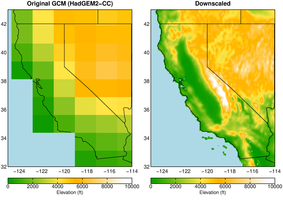
Global climate model representation of California elevations (left) compared to LOCA
A collaboration of university researchers, government agencies, and private sector groups released today a next-generation climate modeling dataset with improved local-scale climate projections covering the 21st century for a region from northern Mexico to southern Canada.
The dataset was produced by researchers at Scripps Institution of Oceanography at the University of California San Diego who developed a new climate “downscaling” method for global climate models known as localized constructed analogs (LOCA). Global climate model pixels can be a hundred miles across, which is too coarse to study many local impacts of climate change. LOCA downscaling estimates finer-scale climate detail from a coarse-resolution global model using a new high-resolution historical observation dataset developed by researchers at the University of Colorado.
The LOCA downscaled climate projections provide temperature and precipitation on pixels that are 3.7 miles (six kilometers) across. LOCA attempts to better preserve extreme hot days and heavy rain events, regional patterns of precipitation, and the future climate changes predicted by the global climate models. The data are daily, covering the period 1950-2100 for 32 global climate models.
“LOCA was developed to address shortcomings in previous statistical downscaling products in capturing climate extremes,” said David Pierce, a climate scientist at Scripps and the lead developer of LOCA. “Extreme events such as heat waves or heavy precipitation have some of the biggest economic and societal impacts, even though they can last just a few days.” Among the applications provided by the new dataset will be investigations of changes in intensity and frequency of occurrence of extreme weather conditions.
Dan Cayan, a climate researcher at Scripps and USGS said that “more spatially specific climate projections are increasingly sought after by natural resource managers, urban planners, and other officials for planning and decision making, which often hinges on having climate change information at local levels.”
Because the new dataset spans from Mexico through southern Canada, it can be used to assess climate impacts across much of North America, including the entire conterminous U.S. A noteworthy example is its prominent role in California’s Fourth Climate Change Assessment, the latest in a series of California state climate vulnerability and adaptation studies undertaken since 2006. The assessment relies on regionally specific climate projections to understand climate change impacts across the state. The fourth assessment, to be completed in 2018, is being conducted by numerous teams of experts who will investigate implications of potential climate change on broad range of sectors including energy, health, wildfire, water, and other natural resources in California.
"At the U.S. Army Corps of Engineers (USACE) we've been very happy to help support development, testing, and deployment of these LOCA model outputs because they directly complement our approaches for creating and using actionable science to inform engineering decisions about climate change threats and adaptive responses," said Jeff Arnold, senior scientist in the Climate Preparedness and Resilience programs at USACE, a collaborator in the project.
Two scenarios of future climate change are included in the dataset. The Representative Concentration Pathway (RCP) “8.5” scenario assumes global greenhouse gas emissions continue to increase through the 21st century. In the RCP 4.5 scenario emissions increase until mid-century, then decline rapidly.
LOCA minimum and maximum daily temperature and precipitation data are available now hosted by several websites listed below. The data are currently being applied to a land surface model, which will additionally provide soil moisture, snow cover, runoff, and other variables needed to study climate change vulnerabilities and impacts throughout the conterminous U.S.
Sponsors, collaborators, and other partners working with Scripps Institution of Oceanography on producing the data include the California Energy Commission, the U.S. Army Corps of Engineers, the U.S. Geological Survey, the Bureau of Reclamation, the NOAA Regional Integrated Sciences and Assessments (RISA) program, the Climate Analytics Group, the nonprofit group Climate Central, Lawrence Livermore National Laboratory, NASA Ames Research Center, Santa Clara University, the Cooperative Institute for Research in Environmental Sciences at the University of Colorado Boulder, and the Southwest Climate Science Center.
Keep up with all the latest from UC San Diego. Subscribe to the newsletter today.

