

SDSC Supercomputer Models Improve Oregon/Washington Coastal Forecasts
Researchers use novel data assimilation methods to increase accuracy
Published Date
By:
- Kimberly Mann Bruch
Share This:
Article Content
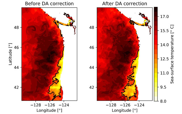
Researchers at Oregon State University have been using the Comet supercomputer at the San Diego Supercomputer Center (SDSC) to test an algorithm that they believe will reduce errors in the widely used three-day forecasts for water temperature, salinity levels, sea heights, and currents off the coasts of Oregon and Washington.
To reduce the forecasting errors, Ivo Pasmans, formerly a doctorate student at the university, and Alexander Kurapov, an Oregon State professor specializing in ocean modeling and data assimilation, used Comet to combine forecasts with observations using an approach called ensemble four-dimensional variational data assimilation (DA), or En4DVAR, which is viewed as a novel oceanographic forecasting tool.
“Running the ensemble of model runs needed by En4DVAR is very time consuming and we could not have used the En4DVAR approach without the 20 processors (480 processor cores) available to us on Comet,” said Pasmans, now a research assistant professor at the University of New Orleans and lead author of a study published in the December 2019 issue of Ocean Modelling.
“To generate an ensemble that realistically represents the model error statistics, we assumed that errors in the model’s wind forcing were the main source of model error, and we built on this concept using satellite wind observations and what’s known as a Bayesian Hierarchical Model to estimate a probability distribution for the wind errors,” explained Pasmans.
With a more reliable three-day forecast, fishing boats can be guided to the best fishing grounds, thereby reducing fuel consumption and improving catch, according to the researchers. Likewise, during a shoreline emergency such as an oil spill, more accurate forecasts would allow government officials to make decisions on how to best accomplish crisis management efforts.
“In general, more accurate predictions of the ocean also allow for more productive search-and-rescue missions,” said Pasmans. “Mostly, though, our Oregon/Washington shoreline is used by fishermen. In the summer there is a strong front in the ocean offshore Oregon, where nutrient rich deep-sea water surfaces and fosters plankton growth and attracts fish such that the correct forecasts of the location of the front can more precisely guide fishing boats.”
“Earth systems such as its oceans are stochastic systems that always contain random components, which make exact forecasts impossible,” added Pasmans. “Thanks to supercomputers such as Comet, however, we were able to run high-powered data assimilation that allowed us to correct these errors to the best of our abilities and generate more accurate forecasts.”
Funding for this research was provided by: the National Oceanic and Atmospheric Administration (NOAA) Coastal Ocean Modeling Testbed (COMT) grant NA13NOS0120139; NOAA Quantitative Observing System Assessment Program (QOSAP), National Science Foundation (NSF) grants OCE-0527168 and OCE-0961999, the Integrated Ocean Observing System/Northwest Association of Networked Ocean Observing Systems (IOOS/NANOOS) grant NA16NOS0120019, and the National Aeronautics and Space Administration (NASA) SWOT Science Definition Team project grant NNX13AD89G. Access to SDSC’s Comet supercomputer was conducted via the National Science Foundation’s Extreme Science and Engineering Discovery Environment (XSEDE) under allocation TG-OCE160001.
Share This:
You May Also Like


Stay in the Know
Keep up with all the latest from UC San Diego. Subscribe to the newsletter today.