

By:
- Ioana Patringenaru
- Lauren Fimbres Wood
Published Date
By:
- Ioana Patringenaru
- Lauren Fimbres Wood
Share This:
UC San Diego at Epicenter of Earthquake Research
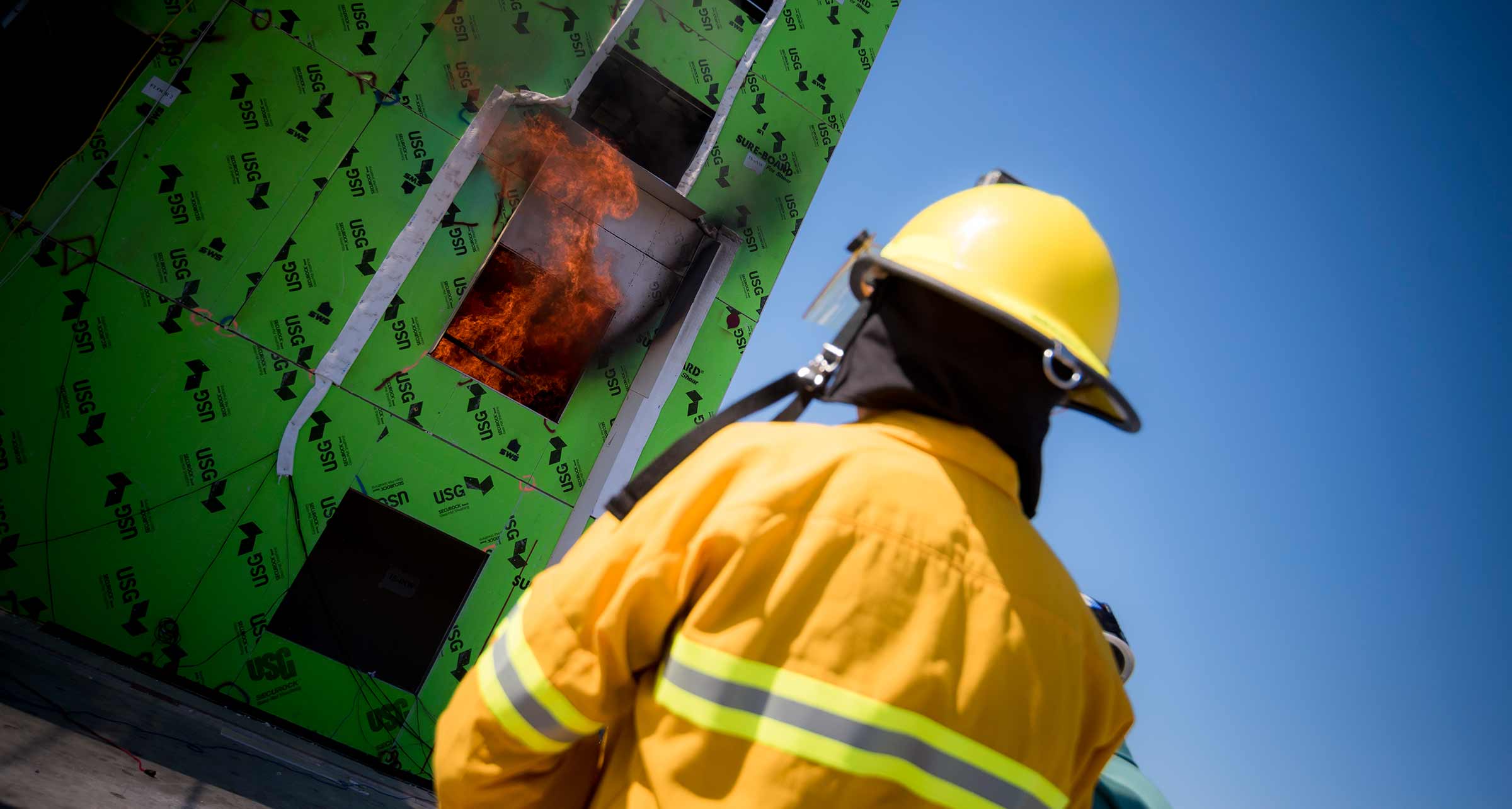
A firefighter looks on as researchers conduct fire tests on a building that has just undergone a simulated earthquake on UC San Diego's shake table. Photo by Erik Jepsen/UC San Diego Publications
From the world’s largest outdoor earthquake simulator to an international network of seismic stations, UC San Diego is a living laboratory for seismic safety. Researchers across campus are trying to improve the understanding and detection of earthquakes; provide immediate information about damages sustained after an event; and improve the safety of structures to better withstand major earthquakes.
As an estimated 9.5 million people across the state are set to participate in the Great California ShakeOut earthquake drill today, scientists at the Jacobs School of Engineering and Scripps Institution of Oceanography are doing their part to keep us safe and provide a better understanding of these natural hazards.
“The Great ShakeOut is a good reminder that we live in an earthquake-prone region,” said Debi Kilb, a seismologist at Scripps who studies aftershocks and is collaborating with U.S. Geological Survey on developing an earthquake early warning system. “It’s a great time to look around and make sure items on the wall and bookcases are secure, and you have an emergency plan and preparedness kit ready.”
The world’s largest outdoor earthquake simulator
The UC San Diego Englekirk Structural Engineering Center in Scripps Ranch has been home to the world’s largest outdoor earthquake simulator, also known as a shake table, since 2004. This fall, construction will start on a major upgrade of the facility, funded by a $16.3 million grant from the National Science Foundation.
In the past 15 years, research at the shake table has led to important changes in design codes for commercial and residential structures and new insights into the seismic performance of geotechnical systems, such as foundations. The facility also has helped validate the use of innovative technologies to make buildings more likely to withstand earthquakes.
For example, in San Francisco, approximately 6,000 so-called “soft-story” wood-frame buildings are being retrofitted to make them safer in strong earthquakes. The buildings all have a first floor with large openings for shop windows or parking, which are vulnerable to collapse during a temblor. Testing of retrofitting systems at full scale on the UC San Diego shake table, led by John van de Lindt, a professor at Colorado State University, was critical to make this possible.
Testing on the table by UC San Diego Professor of Structural Engineering Jose Restrepo and University of Arizona Professor of Civil Engineering Robert Fleischman led to new design standards for what are known as floor diaphragms, structural elements that transfer seismic forces from building floors to columns, walls and eventually foundations.
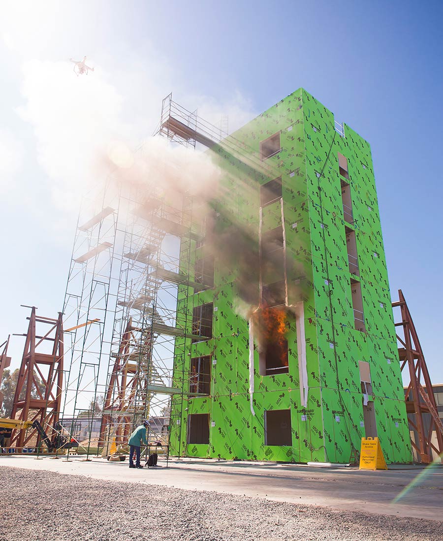
UC San Diego structural engineers partnered with researchers at the Worcester Polytechnic Institute to run fire tests on a six-story light-weight, steel-frame building at UC San Diego's earthquake simulator.
The shake table also has enabled researchers in the UC San Diego Department of Structural Engineering to test complex structures with a range of construction techniques, from masonry, to concrete to steel frames.
“Earthquake engineering is very important for society because engineers help lessen the number of deaths in earthquakes and decrease disruptions on society,” said Joel Conte, a professor of structural engineering and the principal investigator for the NSF-funded shake table upgrade.
Over the next 18 months, the shake table will undergo extensive construction that will reconfigure the facility so that the table will be able to reproduce all six components of ground motion during earthquakes (back and forth in two directions; up and down; as well as pitch roll and yaw).
“The upgrade will create a unique, large scale high-performance experimental research facility that will enable research for the advance of the science and practice of research engineering,” said Lelli Van Den Einde, teaching professor at UC San Diego and co-principal investigator for the NSF upgrade grant.
“We will be able to reproduce earthquake motions with the most accuracy of any shake table in the world,” Conte said.
Being able to reproduce a complete earthquake motion is important because during a temblor, the ground doesn’t just shake horizontally. For example, during the Northridge earthquake in the Los Angeles area in 1994, bridge columns punched through bridge decks, hinting at a strong vertical motion of the ground.
“The upgraded shake table facility will provide an unprecedented and exceptional tool to educate students, as well as the news media, policymakers, infrastructure owners, insurance providers and the public, about natural disasters and the national need to develop effective technologies and policies to prevent these events from becoming societal disasters,” said Van Den Einde.
Powell Labs: testing roads and bridges
A team of researchers from across UC San Diego are using lasers, GPS sensors and drones to create a digital record of Geisel Library that will serve as a baseline health assessment in the event of an earthquake.
On the main campus, many of the advances making California roads and bridges safer during earthquakes were tested at the Charles Lee Powell Structural Engineering Laboratories. In fact, when you drive across a highway bridge in California, there is a good chance that your safety depends on a piece of technology that has been developed and tested there.
One of the laboratories’ many landmark contributions is the assessment of key structural elements for the new San Francisco-Oakland Bay Bridge. The iconic bridge’s eastern span needed to be replaced after being damaged during the 1989 Loma Prieta earthquake.
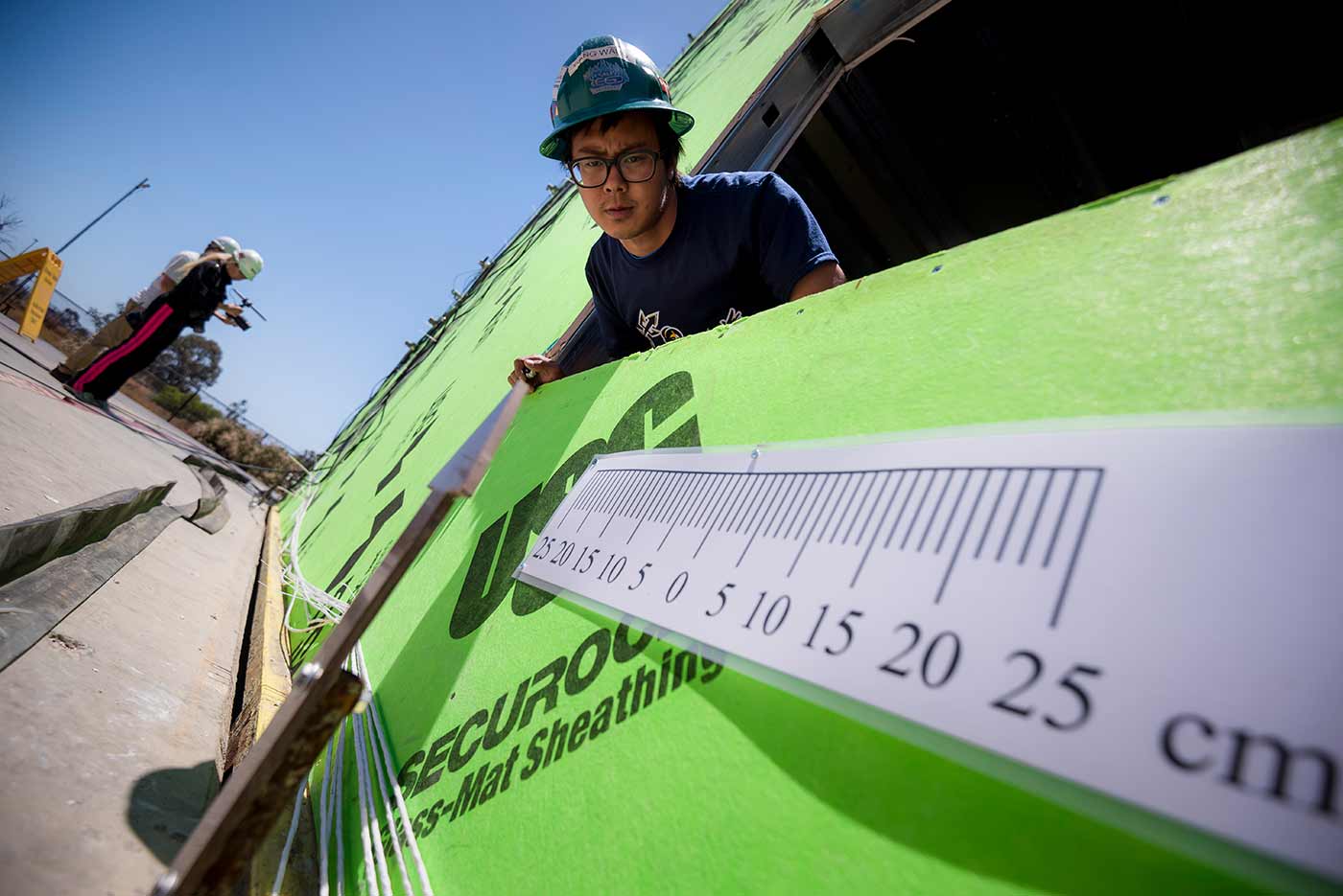
The Powell Labs’ first building is a campus landmark off Warren Mall, especially at night, when the unique neon artwork “Vices and Virtues” by Bruce Nauman flashes around its top stories. Inside, the building is home to a five-story-tall high-bay area with a 50-foot-tall strong wall. The , of its kind in the United States, it is equipped with state-of-the-art facilities for testing large-scale structural systems, capable of simulating very large earthquake forces.
“The Powell Labs helped bring an entire generation of bridges here in California up to code,” said Tom Ostrom, the State Bridge Engineer at the California Department of Transportation and a Jacobs School alumnus during the Powell Labs 30th anniversary in 2017. He is a member of the first class of students to receive bachelor’s degrees in structural engineering at UC San Diego in 1987 and worked as a research assistant at the Powell Labs.
The labs were the “first big monster” in the panoply of research facilities at the Jacobs School, added Chia-Ming Uang, a professor of structural engineering. Over the years, the laboratories added many more unique facilities—the shake table at the Englekirk Center among them.
Geisel Library monitoring
At the very heart of campus, the Geisel Library is not only an architectural gem—it is also a testing ground for monitoring structural health over time and after earthquakes.
An interdisciplinary team of researchers from Scripps Institution of Oceanography, Qualcomm Institute and Jacobs School of Engineering used drones, LIDAR, and global positioning systems (GPS), to create high-resolution baseline data of the structure, so it can be quickly analyzed for damage after an earthquake or other extreme event.
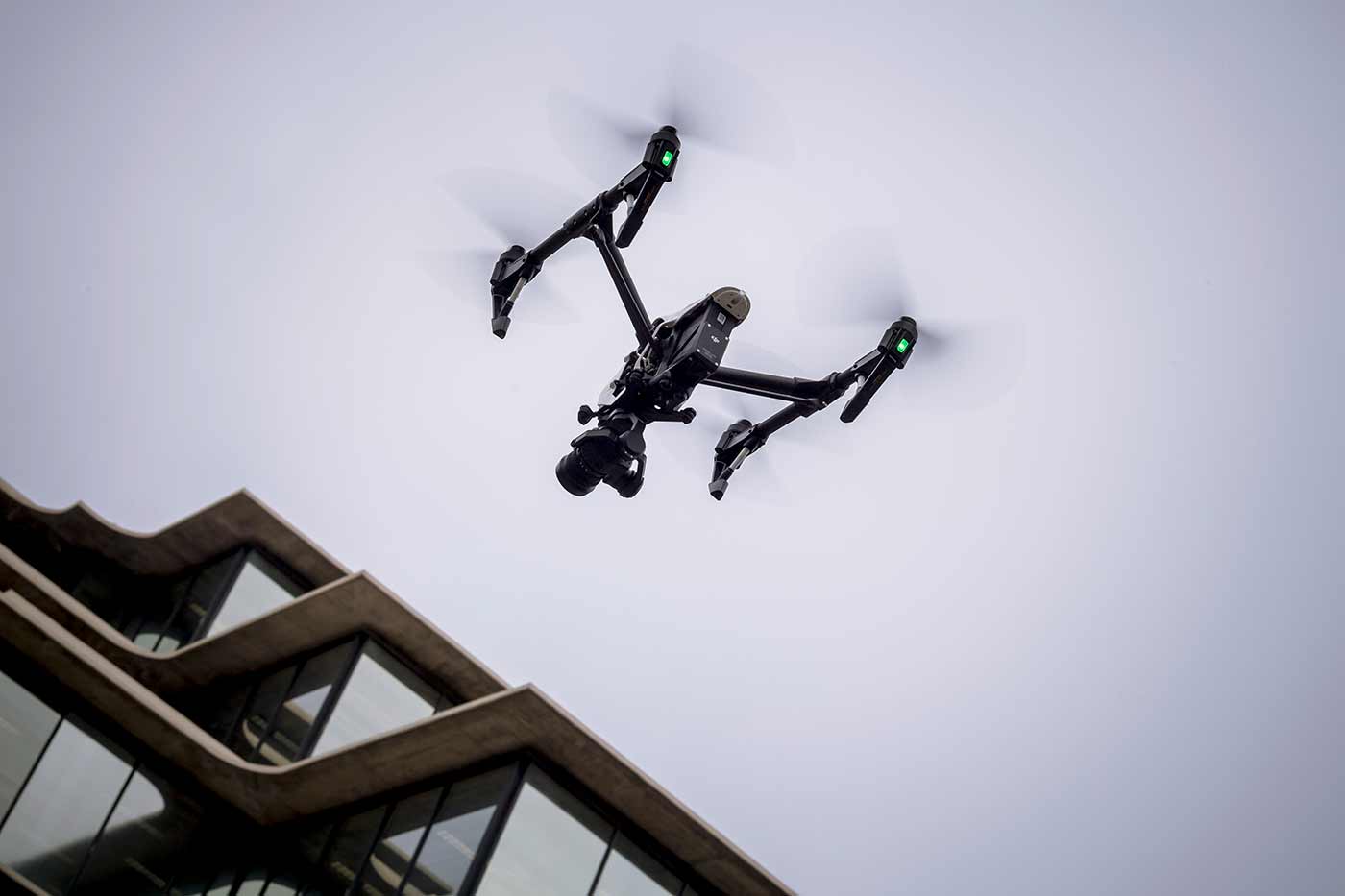
A drone flies a pre-programmed pattern taking thousands of high-resolution images of Geisel Library. The Library has now been digitally surveyed three times.
The technology allows for detection of movement down to the centimeter level, said Scripps researcher Yehuda Bock, a lead collaborator on this project. He says this system offers a more precise analysis of a structure compared to the simple visual inspections currently in use.
Following the 7.1 magnitude Ridgecrest earthquake in July 2019, Geisel Library was digitally mapped for the third time in as many years. Jacobs School robotics engineer Eric Lo conducted a drone flight following a pre-programmed pattern taking thousands of high-resolution images. A ground-based LIDAR (light detection and ranging) survey examined the exterior geometry of the building, and GPS sensors on top and off of the library were referenced to measure any displacement. This combination of technologies was then overlaid to create a photo-realistic, precise 3-D model where change in movement can be quickly assessed.
No displacement was detected after the earthquakes in July. Researchers say that now that the baseline data of the structure exists, the mapping system can be used to monitor the building to swiftly respond if needed following an extreme event.
California Real Time Network
The GPS stations on top of Geisel Library provide continuous measurement, and also feed into a larger network of sensors monitoring movement for the entire state of California.
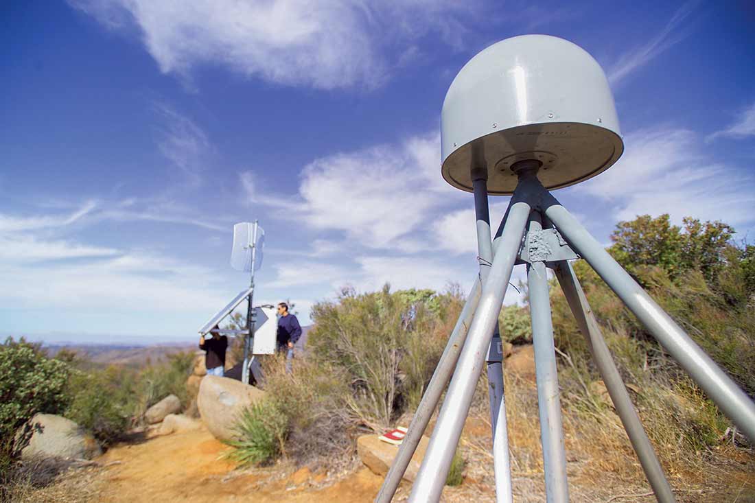
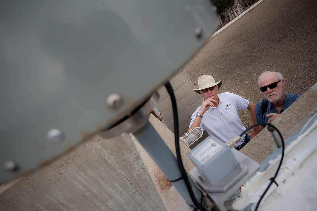
A GPS monument in San Diego County is part of the California Real Time Network that provides geospatial information throughout the state. The data is used to determine where ground movement has happened after an earthquake.
The California Real Time Network (CRTN) is an array of 584 GPS stations that provides accurate geospatial information throughout the state. In the immediate aftermath of an earthquake, the network can provide instant data on where the most movement, or displacement of ground, has occurred. This allows stakeholders such as Caltrans to immediately dispatch crews to check on the structural health of roads and bridges where the most movement was measured to have occurred.
After the July 2019 7.1 magnitude Ridgecrest Earthquake, the GPS station closest to the epicenter showed movement of nearly half a meter,” said Bock, who also oversees the California Real Time Network and a range of projects in geodesy, geophysics, surveying and engineering.
This network is used year-round by entities such as Caltrans, as well as structural engineers, urban planners, intelligent transportation groups, city and county officials, the Army Corps of Engineers and more, who need real-time records of terrain down to the subcentimeter level. Particularly after an earthquake, the survey records then get updated to provide extreme accuracy of the surface terrain, which is needed before building structures, roads, bridges and more.
Earthquake early warning
The California Real Time Network also provides data for earthquake early warning systems. The goal of exploratory earthquake early warning systems is to detect large earthquakes within 1-2 minutes before the severe shaking is felt.
The technique Bock helped pioneer, called seismogeodesy, relies on a combination of the GPS and seismic sensors to very rapidly pinpoint the location and magnitude of strong earthquakes—5.0 magnitude or greater—before the hazardous shaking begins.
The earthquake early warning that Kilb is working on with the U.S. Geological Survey aims to develop a simplified algorithm that looks for major ground motion using seismic sensors on the West Coast, similar to a system that has been effective in Japan. The system would provide seconds of warning via phone messaging to alert people to duck, cover, and hold on.
A structural engineering Ph.D. student checks a gage to see how much a building has moved during a test on the shake table.
Project IDA international seismic network
The shake table isn’t the only earthquake system managed by UC San Diego receiving a major upgrade. Last year, the National Science Foundation awarded a $16.7 million grant to revitalize a seismographic network based at Scripps that provides vital real-time data about earthquakes and other seismic events around the world.
Project IDA (International Deployment of Accelerometers) is a network of broadband seismometers spread across every continent on Earth that provides rapid detection and reporting of seismic waves.
Over the next five years, the funds are being used to install new equipment that can detect smaller and smaller earthquakes, provide better measurements of larger earthquakes, and even detect low-frequency sound in Earth’s atmosphere from volcanic eruptions, meteor strikes, and other phenomena.
The network has 41 stations in 28 countries, and in addition to seismic data provided to scientists around the world, also serves a national security function with its ability to detect explosions that potentially violate the Comprehensive Nuclear-Test-Ban Treaty. Project IDA sensors were among several that provided the data used to determine that a September 2017 event in North Korea was an explosion rather than an earthquake using parameters such as its distance from the earth’s surface and the profile of seismic waves it produced.
Stations in Uganda, Australia, Kazakhstan, Sri Lanka, Costa Rica and the Azores are among those recently upgraded.
“These seismic stations provide valuable data to our international partners where these stations are located,” said Peter Davis, executive director of Project IDA. “The program augments each country’s own seismic monitoring with our technology, and can be an anchor for its local network, helping better pinpoint the location of an earthquake.”
Data from these seismometers can also assist with analysis of undersea earthquakes that may drive tsunamis. The data is transmitted in real time to UC San Diego, then streamed instantly to global tsunami warning centers monitoring for these events.
Ridgecrest earthquake research
Beyond structural testing and observation systems, seismologists at UC San Diego are also working to understand the complexities of earthquakes after they happen, to continue advancing the scientific understanding of earthquake behavior.
For scientists at Scripps, that meant making a trek to Ridgecrest, Calif., in the aftermath of the magnitude 6.4 and 7.1 earthquakes that struck in July to deploy sensors and look for surface ruptures, or new, visible breaks in the ground.
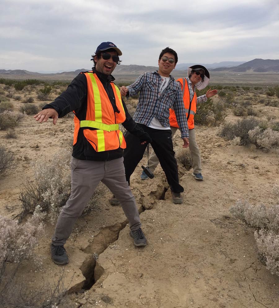
Scripps Oceanography geoscientists Ignacio Sepulveda, Xiaohua Xu, and Jennifer Haase straddle a fault offset that formed in Ridgecrest, Calif., following the magnitude 6.4 earthquake that struck in July. Before the earthquake, their feet would have been next to each other, illustrating the significant left-lateral ground rupturing that occurred.
Postdoctoral Scholar Xiaohua Xu and geophysics professor David Sandwell were part of the group that made the four-hour drive to Ridgecrest, where the team installed GPS monuments or sensors to understand how the crust had moved. What they found were some dramatic vertical offsets, or major shifts in the ground.
“There was a lot of fracturing in the entire area,” said Xu. “It was a shallow earthquake, which seems to have led to more fracturing and surface ruptures than is typical for earthquakes that size.”
Xu says while they are still studying the aftermath of the earthquake, they believe this fracturing could be because the fault is a newly discovered one or a relatively immature fault, and the thick sediments in the area were more susceptible to cracking compared to rocks.
Research teams from Scripps have made four visits to the Ridgecrest area, each time adding more GPS sensors and doing maintenance on those installed on prior trips. Xu is also leading research analyzing InSAR satellite data, which can measure crustal motion and crustal deformation at the surface. The satellite data enables researchers to measure millimeter-level movements. Ultimately, all of this post-quake analysis is teaching scientists more about earthquake behavior and the mechanical properties of the Earth’s crust.
“We don’t have a definitive understanding of earthquakes or tsunamis, because they all behave so differently and they are very complex systems,” said Ignacio Sepulveda, a postdoctoral fellow working with geophysicist Jennifer Haase primarily focused on tsunami warning and tsunami hazard assessment, who assisted with the field work.
For those concerned about what Ridgecrest could mean for the implications on the San Andreas Fault, the major fault that runs nearly through the entire state of California that is believed to be overdue for a great earthquake, Scripps geophysics professor Yuri Fialko is studying just that.
He says the Ridgecrest earthquakes, and other similar ones like the 1999 Hector Mine earthquake, caused displacements on the shallow part of the Southern San Andreas Fault. The triggered displacements increase stresses on the deeper locked parts of the San Andreas, thereby advancing the clock for the next earthquake.
Another possible effect of the Ridgecrest earthquake on other active faults in southern California, including the San Andreas, is a redistribution of stress changes caused by the earthquake in the deeper parts of the Earth’s crust below the active faults. A team led by Fialko deployed GPS receivers to study these processes in the Earth’s crust in months and years following the earthquake.
“Every time there is a major earthquake, we have a large-scale experiment set up for us by nature,” Fialko said. “We just need to be able to detect the relevant signals. The Ridgecrest earthquake will be an important data point.”
These additional data points help improve understanding of earthquakes, which could ultimately lead to better and safer infrastructure engineering, public awareness on how to stay safe during these events, and advance warning of these phenomena.
Share This:
You May Also Like


Stay in the Know
Keep up with all the latest from UC San Diego. Subscribe to the newsletter today.